Linking Rivers -A Remote Sensing and Geographic Information System (GIS) Approach
ndia
is blessed with abundant water resources, which are unevenly distributed
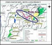
in space GIS TO SOLVE THE ISSUES OF INTERLINKING Technical Issues n Drinking water supply to towns and villages enroute: It is worthwhile to plan for domestic water supply to towns and villages enroute. Water supply network can be planned in GIS environment to carry out route tracing and resources allocation. n Water allocation for irrigation: Optimum usage of water for irrigation has to be facilitated by distribution channels up to the agricultural field from the link canals. This involves planning of field channel network so as to divert the water from the main link canal. Quantity of water can be metered and monitored. The above aspect can be very well planned using network analysis capability of GIS. n Command area development: Command area development involves suggesting cropping pattern to suit the region, providing proper drainage system, soil conservation, irrigation facilities, water harvesting and credit systems for the farmers and related activities. The spatial analysis capabilities of Remote Sensing and GIS will offer excellent facilities towards the planning of the command area along with the link canals. Environmental Issues n Land submergence: The extent of land submergence due to the alignment of the canal and construction of reservoirs and hydraulic structures can be assessed and analysed with the functionalities of GIS before the initiation of project so that alternatives can be planned accordingly. n Forest Cover: Remote Sensing and GIS are used for forest cover assessment. Temporal variation of satellite images is used for chage detection analysis and impacts of link canal. n Ecology: Ecological aspects consist of studying the rare species located in the project area. The project canals, reservoirs and other irrigation structures may be planned accordingly so that the species are not affected to the maximum extent possible. GIS will support the spatial analysis of the above feature. n Water logging and Soil Salinity: Soil characteristics salinity and water logging along the canal alignment has to be studied in detail so as to avoid those zones or to suggest remedial measures. n Land Acquisition and Rehabilitation: Spatial database consisting of land and persons affected due to the project can be developed in GIS environment. The spatial analysis capabilities of GIS will speed up the completion of entire process of land acquisition and other aspects of Relief and Rehabilitation. Socio-Economic Issues The spatial socio-economic assessment with respect to various issues such as gender, social status of the people, cropping pattern, traditional practices with respect to occupation, and other related aspects at micro level can be prepared using GIS. Study on Ken-Betwa Link Development Alternatives is doing a small study on Ken-Betwa link with the following objectives. n To study the alignment of the link canal in order to verify the route and check whether it has any significant implications. n To assess the present landuse using satellite Remote Sensing data and then verify the landuse by extensive field survey and thereby suggesting the proposed landuse. n To assess the number of villages and the population which would be impacted by construction of the canal. n To study the catchment area of the dam to be constructed on the Ken River at Daudhan, from where the link canal will be initiated. q
Anand
Kumar Reference: www.gisdevelopment.net/technology/gis/ma03203.htm |
 and time. When one part of the country is reeling under severe water
scarcity, floods cause destruction in another part. India experiences
extremes of climate within the 329 M ha of geographical area. Mean
annual rainfall varies from 100 mm in western Rajasthan to over 11000 mm
at Cherrapunji in Meghalaya (Indian Water Resources Society, 1994).
Flood prone areas of 40 M ha and drought prone areas of 51 M ha are
being affected in India. Some rivers are perennially dry and some rivers
discharge huge quantum of water to the sea every year. This necessitates
the surplus and deficits to be redistributed for the betterment of the
whole country through the massive task of interlinking of rivers.
Interlinking of rivers involves multidisciplinary data on hydrological,
environmental, agricultural, socioeconomic and political aspects. This
data is derived from various sources such as toposheets, remote sensing
imagery, aerial photographs, paper maps and field data. For decision
making on such complicated project issues, the related data and
information should be stored at one place in digital form for easy
retrieval, updation and analysis for effective planning and execution
purposes. GIS, a powerful spatial technology, provides the scientific
environment to store and analyse multidisciplinary data for solving such
real world problems.
and time. When one part of the country is reeling under severe water
scarcity, floods cause destruction in another part. India experiences
extremes of climate within the 329 M ha of geographical area. Mean
annual rainfall varies from 100 mm in western Rajasthan to over 11000 mm
at Cherrapunji in Meghalaya (Indian Water Resources Society, 1994).
Flood prone areas of 40 M ha and drought prone areas of 51 M ha are
being affected in India. Some rivers are perennially dry and some rivers
discharge huge quantum of water to the sea every year. This necessitates
the surplus and deficits to be redistributed for the betterment of the
whole country through the massive task of interlinking of rivers.
Interlinking of rivers involves multidisciplinary data on hydrological,
environmental, agricultural, socioeconomic and political aspects. This
data is derived from various sources such as toposheets, remote sensing
imagery, aerial photographs, paper maps and field data. For decision
making on such complicated project issues, the related data and
information should be stored at one place in digital form for easy
retrieval, updation and analysis for effective planning and execution
purposes. GIS, a powerful spatial technology, provides the scientific
environment to store and analyse multidisciplinary data for solving such
real world problems.