| Application of Geo-information Technologies
for Integrated Watershed Management India is a major agricultural economy, with more than 70% of the population depending on farming for their livelihoods. Nearly three quarters of India’s agriculture is monsoon-dependent; this area contributes nearly 42% of total agricultural production. But the monsoon season has not remained uniform over the years.
The productivity of any crop hinges on two natural resources: those of land a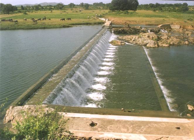 nd water. Management practices play a crucial role in the success of agricultural activities. Therefore, the conservation of these two natural resources is essential to the sustainability of rain-fed agriculture. Land and water are the basic natural resources for biomass production; they constitute the core of ecological systems. The very base of production is under great stress in many parts of our country due to severe biotic pressure and ever-intensifying development, as evident from the current scenario and projected demands. The current scenario and future projections amply demonstrate that scientific planning and natural resource management have now become an imperative rather than an option for the sustainable development of our country. In recent times, the development of land and water resources is being planned on the basis of natural hydrologic entities (watersheds) rather than administrative boundaries. Such development plans are practiced on a sustained basis, preventing the deterioration of local ecosystems and ensuring increased productivity for the benefit of the people. nd water. Management practices play a crucial role in the success of agricultural activities. Therefore, the conservation of these two natural resources is essential to the sustainability of rain-fed agriculture. Land and water are the basic natural resources for biomass production; they constitute the core of ecological systems. The very base of production is under great stress in many parts of our country due to severe biotic pressure and ever-intensifying development, as evident from the current scenario and projected demands. The current scenario and future projections amply demonstrate that scientific planning and natural resource management have now become an imperative rather than an option for the sustainable development of our country. In recent times, the development of land and water resources is being planned on the basis of natural hydrologic entities (watersheds) rather than administrative boundaries. Such development plans are practiced on a sustained basis, preventing the deterioration of local ecosystems and ensuring increased productivity for the benefit of the people.
Geo-information technologies yielding high-resolution (spatial and spectral) satellite data have recently become available. The scope and application of satellite data, in combination with the GIS, has proved to be extremely useful in micro-level planning and implementation. Such technologies assist in the observation, measurement, mapping and monitoring of the earth’s natural resources. Remote satellite sensing, in conjunction with GIS, is an excellent tool for natural resource assessment and management as well as micro-level planning and implementation.
Watershed planning and management of soil and water conservation programmes require scientific information as an essential input for selecting appropriate conservation measures and making them technically and economically effective. Each watershed has its own problems, potential, prospects and developmental needs under a set of geophysical, climatic, demographic and socio-economic conditions. Reliable information pertaining to area-specific potentials and problems as well as the specific needs of the people is essential for evolving concerted local action plans. The development of land and water resources within a watershed is best handled by state-of-art tools, remote sensing and GIS. There is a need for correlating resource inventories with information regarding farmers’ socio-economic conditions within a watershed area.
Geo-information technology enables us to strengthen programme management and coordination, undertake activity-based project planning, formulate action plans, streamline sanctions and release of funds, create useful databases, assess actual project impacts, make effective prioritisations, prepare sophisticated (detailed project reports) DPRs, document best practices and case studies and facilitate the free and seamless flow of information and data. Remote sensing data should be used for finalising contour maps for run-off assessment and for identifying structures best suited for project location. This will result in cost and time optimisation in project implementation. Technology can also contribute immensely to the successful assessment of the actual impact of various programs in a given area. Due to the availability of the latest remote sensing techniques, it is now possible to assess periodic changes in geo-hydrological potential, soil and crop cover, run-off and so forth in project areas.
Resource Database
Since watershed development programmes are implemented in a spatial domain, it is necessary to have a sound resource database and thematic maps on geology, hydro-geomorphology, soils, land use and land cover as well as land degradation status, amongst other indicators. This can be achieved through the application of the Remote Sensing technique that provides data in different combinations of spatial, spectral and temporal resolution. Remote Sensing being multi-disciplinary, single satellite imagery provides information on many aspects of watershed management. The spatial database/thematic maps pertaining to soils and land capability, land use/land cover, hydrogeology, ground-water potential (hydro geomorphology), slope, drainage, watershed boundaries, transport network, village boundaries can be immensely useful in providing baseline information to this end. These thematic maps provide detailed data regarding major watershed characteristics. Most of the contents of the natural resource database are being generated using satellite data. Hence, the satellite imagery also acts as a provider of baseline information during the impact assessment studies using Remote Sensing techniques.
Integration of Information in Thematic Maps and Action Plan Generation
The action plan for the area should be optimally suitable to the terrain and to the productive potential of local resources, so that the level of production is sustained without decline over time. Recommended activities of the action plan should take into consideration contemporary technology and resources and climatic and terrain parameters. The integration of thematic maps can be achieved systematically through the following steps:
Step 1: Study of individual thematic maps
The individual thematic maps are to be studied by a multi-disciplinary team in order to make a spatial assessment of the relative variations in resource potentials and range of terrain conditions. This analysis helps in understanding the peculiar nature of the area and its related problems requiring special attention. For example, problems unique to a particular area such as drought, flood, wasteland, land degradation, decline of the water table and change in land use / land cover can be inferred from this quick analysis.
Step 2: Study of thematic maps in combination
The natural and logical association of single-theme parameters with other themes is studied for better understanding cause and effect relationships with respect not only to problems/limitations, but also to the potential that exists in the watershed.
Step 3: Development of decision rules
1. Land resource development and management: a number of spot observations are made covering almost all types of land forms, soil, slope, groundwater potential and quality, rainfall and climate zones, present land use and so forth. Spot observations should be highly intensive, though intensiveness will vary depending on the variability existing in the study area. All these observations are to be compiled as per recommended land use options/practices. Accordingly, for a particular recommendation or combinations of recommended land use practices, various types of combinations of land parameters are developed, which serve as the decision rules for the integration of thematic maps and preparation of action plans. A decision rule has to be area-specific and therefore has to be developed for each study area.
2. Water resource development and management: water resource development and management greatly influence the land resource base. Therefore, it is necessary to develop, conserve and efficiently utilise the available soil and groundwater.
Step 4: Preparation of draft action plan
The action plan can be prepared using the decision rules by overlaying the thematic coverage through GIS. Integration of various themes can be done by overlaying one theme over the other progressively and by applying suitable decision criteria as suited to the terrain.
Step 5: Finalisation of action plan
The draft action plan is to be discussed with line department officials, district administration, local research centres, NGOs working in the area and farmers for their feedback. On suitable incorporation, the draft action plan has to be validated on the ground for improving the accuracy. The action plan is then finalised by incorporating field observations. 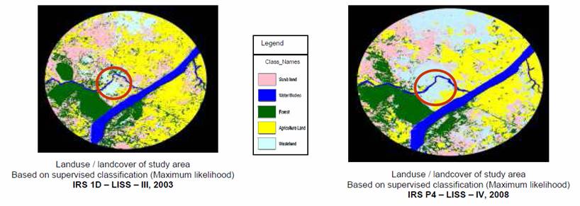
Watershed Monitoring and Impact Evaluation
As the watershed development approach is an integrated one that incorporates the involvement and efforts of various departments and requires a considerable budget, there is a need for a suitable set of indicators to assess the progress of implementation. It is necessary to holistically assess and evaluate the long-term effects and the impact of the activities through reliable methods. Conventional, ground-based sampling has proved to be costly and time-consuming. Repetitive satellite coverage provides us with an excellent opportunity to monitor land resources and evaluate land cover changes through a comparison of images acquired for the same area at different times. Changes in increased area under cultivation, clearing of natural vegetation, conversion of annual cropland to horticulture, changes in surface water spread/levels, changes in the extent of irrigated area, afforestation, post-fire impact, soil disturbances due to mining, large landslides etc., could be monitored through satellite remote sensing. Changes can be determined by comparing spectral response differences at the same spatial location among a set of two or more multispectral data acquired at different times. There are many change detection algorithms using digital techniques like image differencing, image ratioing, normalised difference vegetation index (NDVI), principal component analysis and comparison of classified images. Over the years, satellite data has proved its utility in detecting and determining the extent and nature of changes over a period of time. The monitoring and evaluation study would provide insight into the impact of development activities in the watershed area and also provide feedback for making necessary modifications, plan revisions and prepare future watershed development projects.
Future Approach to Watershed Management
People’s participation is key to the success of any watershed development programme. Awareness, commitment, participa-tion and response are essential to achieving these objectives. The approach should emphasise participatory management and involvement of the local community right from the planning stage, which helps in the smooth and effective implementation of the program. The success of community participation depends upon group discussions, working together and united efforts. Motivation is an important aspect of getting the needed responses from the community, and response levels depend upon the modus operandi in establishing rapport, convincing the community, appropriateness of the technology and reaching the farmer in his own language. Demonstration and exhibition of results showing economic benefits and making arrangements for finances, implementation and marketing would ensure effective participation. It is in this context that non-governmental organisations (NGOs) and voluntary agencies have the capacity to draw good response levels, and to be instrumental in building a better rapport and confidence as well as in translating the organisational expertise required to manage the resources within their watershed. A new era should begin towards sustainable development by evolving a development plan with a high level of community participation, utilising scientific planning tools like satellite imagery and GIS to help the local people build a sustainable future with their own hands.
Integrated Watershed Management in Bundelkhand
Development Alternatives is currently implementing the Integrated Watershed Management Programme (IWMP) in the Datia and Tikamgarh districts of the Bundelkhand region with the support of the Government of Madhya Pradesh as per the IWMP guidelines. q
Anand Kumar
akumar3@devalt.org References
Krishnayya, J. G., Baruah Angira, Use of Geographic Information System (GIS) tool in watershed hydrology and irrigation water management, http://www.gisdevelopment.net/application/nrm/water/watershed/watws0004.html.
Chowdary, V.M., Paul, Saiket, Srinivas Kumar, T., Sudhakar, S., Adiga, S., Nageswara Rao, P.P., Remote Sensing and GIS approach for watershed monitoring and evaluation: A case study in Orissa state, India.
http://www.crisp.nus.edu.sg/~acrs2001/pdf/287chowd.pdf.
Rajora, Rajesh, Integrated Watershed Management - A Field Manual for Equitable, Productive and Sustainable Development, Rawat Publications, Jaipur and New Delhi, pp. 195-199.
Sinha, A.K., Remote Sensing and Geographic Information System In Watershed Development, National Workshop on Participatory Watershed Development, February - 27, 2003 - March - 1, 2003. Back to Contents |