|
Role of
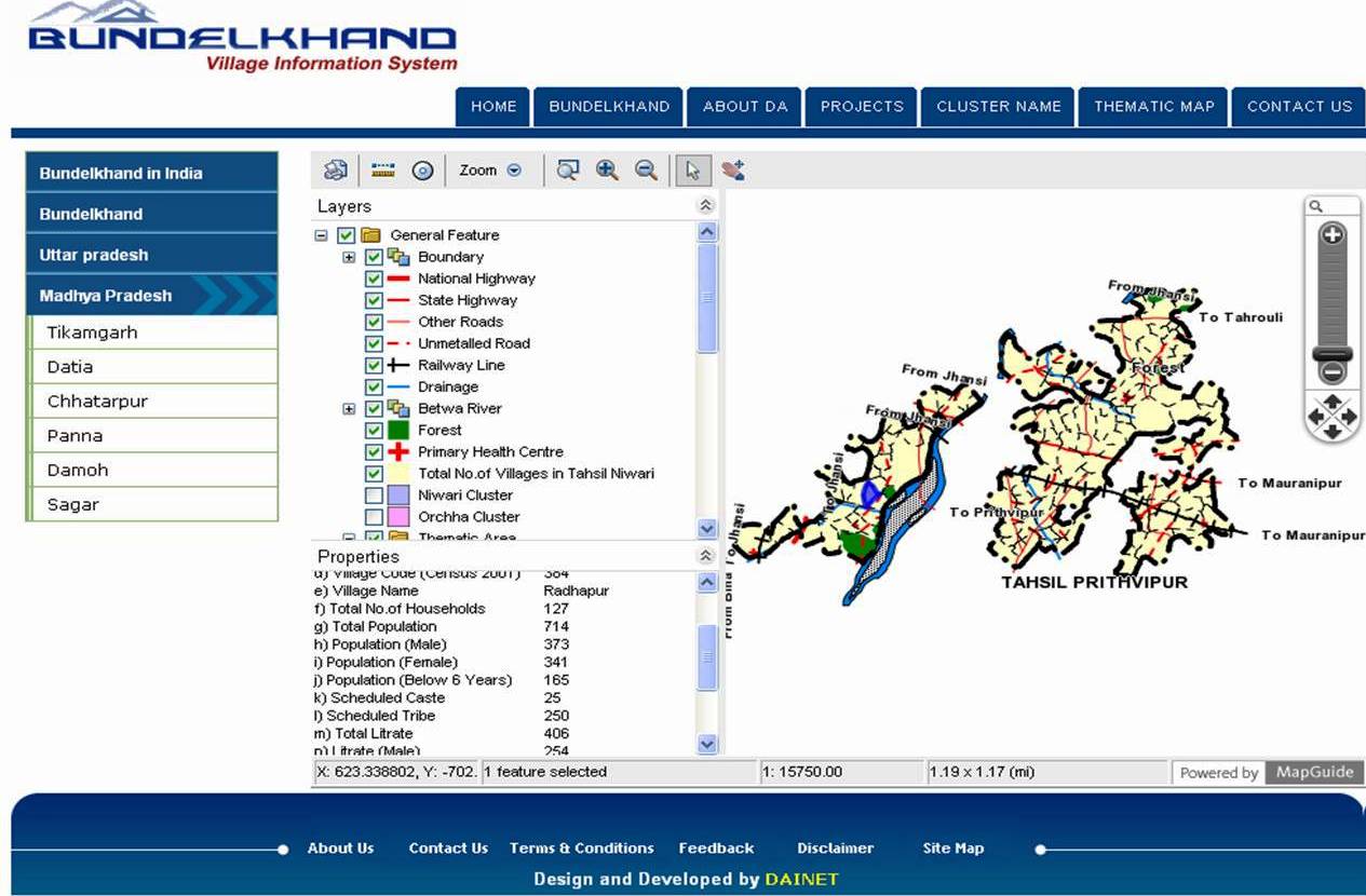
GIS as a tool in Climate Change E arth’s climate has undergone radical changes in the distant as well as in the recent past and is almost certain to undergo more changes in the future. As industrialisation, population and urbanisation continue to increase, so too will stressors on the environment such as pollution. Such change in climate and environmental quality will definitely have huge implications for quality of life.We live in an age of readily and freely available information. The internet has given us unprecedented awareness of and access to vast quantities of climate data. Never before scientists had such easy and open access to the data and tools needed to study earth’s climate. Both past observations and future predictions are useful in studying climate change. Examining and cross-referencing past and future data can help quantify changes already occurring as well as predict patterns and trends that could impact climate in the near and long-term future. What is GIS? Making decisions based on geography is basic to human thinking. Where we shall go, what it will be like, and what we shall do when we get there are applied to simple events like going to a shop as well as major events like launching a deep sea submersible into the ocean’s depths. By understanding geography and people’s relationship to location, we can make informed decisions about the way we live on our planet. A geographic information system (GIS) is a technological tool for comprehending geography and making intelligent decisions. GIS organises geographic data so that a person reading a map can select data necessary for a specific project or task. A thematic map has a table of contents that allows the reader to add layers of information to a base map of real-world locations. For example, a social analyst might use the base map of Tikamgarh, Madhya Pradesh, and select datasets from Census of India to add data layers to that shows population, sex ratio, literacy rate, and employment status. With the ability to combine a variety of datasets in an infinite number of ways, GIS is a useful tool for nearly every field of knowledge from town/city planning, district planning to forest conservation and tiger conservation and even to climate change. GIS maps are interactive and users can scan a GIS map in any direction, zoom in or out, and change the nature of the information contained in the map. They can choose whether to see the roads, how many roads to see, and how roads should be depicted. Then they can select what other items they wish to view alongside these roads such as drains, electric lines, rare plants, or hospitals. Some GIS programmes are designed to perform sophisticated calculations for tracking storms or predicting erosion patterns. GIS and Climate Change Climate is a complex system and it involves air, water, ice, land and various other actions like water cycle and greenhouse effects. To understand climate, it is essential to create a framework for collating different pieces of past and future data from a variety of sources and merge them into a single system. GIS/Information technology brings together data from these many different sources into a common computer database. GIS is a sophisticated technology tool used by planners, engineers, and scientists to display and analyse all forms of location referenced data, from meteorological information to patterns of human settlement. GIS can be used for creating a new framework for studying climate change by allowing users to inventory and display large, complex spatial datasets. GIS can also be used to analyse the potential interplay between various factors for an understanding of how our dynamic climate may change in the coming decades and centuries. To understand climate change, we need to understand the interconnections between the complex systems that sustain our planet. The rising temperatures, and the changes in precipitation, evaporation rate, runoff and wind speeds are causing more droughts and more severe storms, sea levels are rising, and these changes are causing damaging shifts in habitat that are harming plants and animals, even to the point of probable mass extinction of many species. Climate change poses a far greater threat to human civilization than individual conflicts, local natural disasters or economic crises. The ecosystem-level changes that are taking place require a much broader outlook and multidisciplinary understanding of what is taking place. GIS can provide the means to measure and monitor the change in temperature level, amount of precipitation, evaporation rate, runoff and wind speeds and can compare and overlay the information to make sense of the full scope and impact of the changes. GIS helps in easy aggregation of cross-disciplinary information about individual locations, regions, countries, continents and the globe. GIS can provide means to measure, monitor and visualise the changes for a clearer picture of climate change impacts. The need for meaningful understanding of the changes and their collation at one place in order to adapt or react can be easily fulfilled by using GIS tools and by developing GIS models. GIS Models can help in predicting changes before hand which can help to mitigate the impact before the adverse situation arises.
GIS can be used to read meteorological data as features, points, or polygons, and for carrying basic statistical operations on the resultant layers repeatedly for temperature, precipitation, evaporation, runoff and wind speeds. Cities and meteorological stations can be represented as points. Areas/regions/countries/continents can be represented as polygons. This way, GIS has much bigger role to play in climate change studies. Climate change is a difficult, complex, politically charged, and vital issue. Every aspect of climate change affects – or is affected – by geography, be it at a global, regional, or local level. To help us better understand such geographies, GIS is the single most powerful integrating tool for inventorying, analysing, and ultimately managing this extremely complex problem. q
Avanindra Kumar Reference |